 The work on mapping the pedestrian-biking trails in the valley of the Tamiš river was a challenge in terms of structuring zones in which a walk or bicycle can be conducted step by step with the possibility that, in addition to phytic activities, it will experience nature in all its ecological aspects.
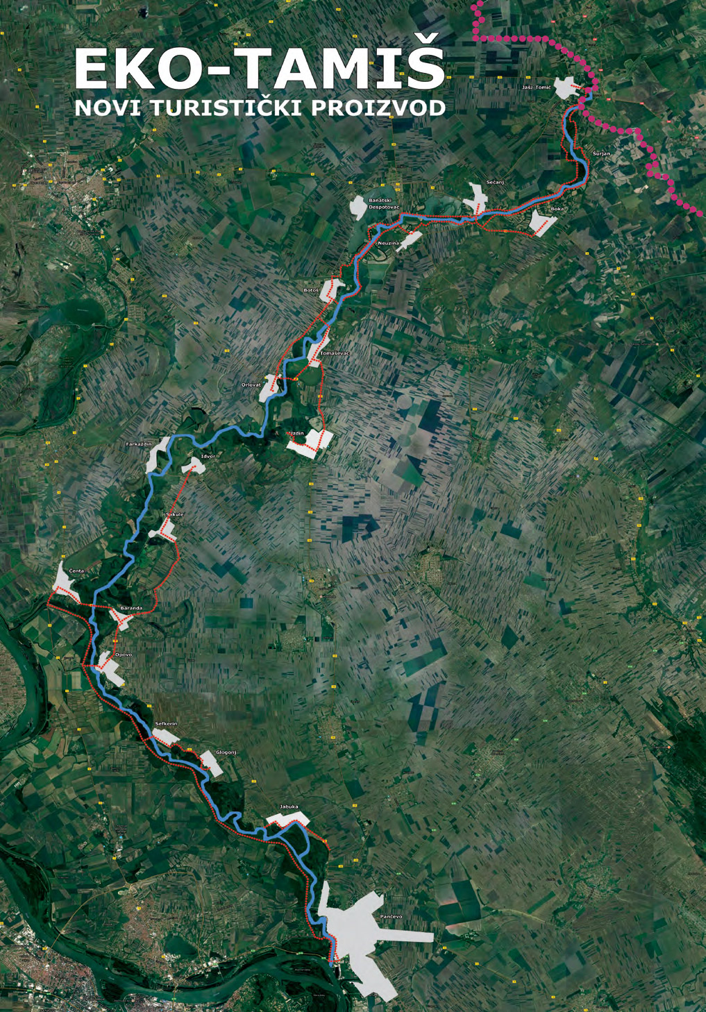
Considering the ecological character of the Project and the goal of creating a new ecological tourism from the valley of the Timiş River, a tourist product available to both domestic and foreign tourists in the analysis was given the advantage of non-paved paths that do not go through inhabited areas (mainly) in order to experience a potential walker / cyclist the user of the ecotourism product was complete.
Due to the characteristics of the river Tamiš, which, as a typical lowland plain, flows in many ways, creates numerous sleeves, dead streams, barbed areas and similar forms of plain waters, and due to the safety of potential users, the accent was on the use of existing defense dams along the Timiş ( where they exist). How they are made in zones where Tamis previously swam the “network” paths that can be used is diverse and different concentrations and lengths. But it is precisely this character that allows for a kind of tourist “connection” of the settlements along the stream and the possibility of planning a visit to different cultural and historical units, which is very important for the potential tourist.
The level of traction is also important for potential users. The theoretical descriptions of the character and interests of an average adventurous tourist who prefer to visit unregulated and “wild” environments in which they have a better contact with nature and in which they feel better fit with the level of obluctuation that is mainly planned in this analysis. Cluttered, not overly edited, surrounded by high plants, perfectly fit into the profile of destinations that eco tourists like to visit. As the inhabited areas are located near or on the banks of the Tamis River, this is another argument that increases their attractiveness, because it gives them the possibility, apart from the experience of nature, to have a discerning character of the journey.
 The characteristics of the course also determine the way they are used by the bicycle. And these possibilities are also in line with the basic, theoretical principles of adventure tourism and these are as natural as the terrain, physical effort during the stay, but also the ability to travel and learn something new about the area you are visiting . On the paths analyzed in this mapping, it is envisaged to ride bicycles with wider tires, the so-called terrain munitions that give drivers the ability to easily overcome the existing unevenness and possible smaller, water-prone parts of the track. Such a ride will be the satisfaction of the users and provide them with the possibility of physical driving challenges even on a level playing field which by their characteristics is not, in itself, challenging to drive in the hilly and mountainous areas.
The valley of the Tamiš river in a part of the river in Serbia has been divided into several zones so that it could be easier to formulate in some future tourist offerings which could be consumed on a daily or weekend visit that prevails in today’s tourist offer.
This, of course, does not mean that the only way to visit the weekend and a one-day visit, but such a division has been made in order to better adapt the future segmentation to potential people who lead a fast life, they always lack the time, want to meet their needs in a short time for physical effort and enjoyment in untouched nature and learn something new about the region, town, village … who visit.
The division into the zone is conditional due to the fact that some of the tracks are quite long (over 40 km) so anyone who wants to overcome them by walking should have to pass through several zones, and spend the night in some of the places that are on their way . The part is made primarily for the so-called average users who will be enough to walk along the trail a few kilometers and return to the place from where they started, without ambitions to overcome the complete path. Because of this, the zones are made more as a whole of neighboring places that can be visited in one day without some great effort of “ordinary” tourists. Less is taken into account “fanatics” who already set themselves new borders on their own daily basis and who will overcome these paths in their own way, making their own itineraries, using the experience they have.
Therefore, the network of tracks is divided into six zones.